ENGAGEMENT EXAMPLE 03 / ROBOTICS + MINING / SAFETY-CRITICAL DEPLOYMENT
Autonomous inspection robotics for underground mines
Identifying which robotic architecture can gather decision-grade evidence after blasting or during restricted access, under the actual mine geometry, atmosphere and communications constraints.
MISSION SET
5 inspection gates
EVIDENCE SET
168 records*
PLATFORMS
16 profiled*
INDICATIVE TIMELINE
5 weeks*
The challenge
An underground mine operator wanted to reduce human entry into newly blasted headings and other temporarily restricted areas. The required mission combined ground-condition imaging, three-dimensional mapping, thermal inspection and multi-gas sensing. The team needed to compare tracked, legged, wheeled, aerial and tethered robotic platforms, but vendor specifications did not show whether the systems could complete the full mission without losing communications, localisation or recoverability.
The representative route included narrow drifts, gradients, loose rock, standing water, airborne dust, low light and several non-line-of-sight turns. A robot could demonstrate strong locomotion in a controlled tunnel yet remain unsuitable if its sensor windows foul, localisation drifts, radio performance collapses around corners, battery endurance excludes the return journey or no safe recovery method exists after a mobility fault. In coal or other gassy mines, electrical and communications equipment may also require jurisdiction-specific approval or permissibility evidence.
The near-term regulatory dimension is relevant for suppliers placing autonomous mobile machinery on the EU market. Regulation (EU) 2023/1230 applies from 20 January 2027 and addresses foreseeable evolution of autonomous behaviour, obstacle detection, remote supervision and safe response to control or safety-system failure. For United States gassy underground mines, the evidence review must separately identify MSHA approval and certification implications rather than assuming that a general industrial robot specification transfers to the mine.
PUBLIC CONTEXT USED TO GROUND THE RESEARCH SCENARIO
The scenario is grounded in the current EU Machinery Regulation, MSHA equipment-approval information and NIOSH mining-safety research. Regulatory requirements are mapped by intended geography and mine type; the research does not provide product certification or a deployment safety case.
Operational scope
MISSION AND ENVIRONMENT
- Post-blast re-entry, unsupported-heading inspection and remote atmospheric assessment
- Low light, dust, water, rubble, gradients, narrow turns and intermittent communications
- Route length, return reserve, operator standoff distance and recovery access defined by the mine
- Coal or gassy-mine scenarios separated from non-gassy hard-rock applications
ROBOTIC ARCHITECTURES
- Tracked, wheeled and legged ground robots
- Aerial robots for rapid visual access and vertical features
- Tethered platforms where power, data or physical recovery justify the constraint
- Hybrid relay concepts using deployable communications nodes
SUBSYSTEM EVIDENCE FIELDS
- Grade, obstacle clearance, traction, ingress protection, payload, endurance and thermal range
- LiDAR, RGB, thermal, acoustic and multi-gas payload performance under stated conditions
- Localisation drift, map completeness, communication latency, packet loss and autonomy mode
- Intervention frequency, fault response, emergency stop, recovery method and mission completion
RESEARCH EXCLUSIONS
- No site-specific hazard assessment, functional-safety validation or certification conclusion
- No field trial, communications survey or explosion-protection test
- No platform ranked from brochure specifications alone
- No surface, warehouse or open-pit evidence transferred without an explicit relevance qualification
How the research would be executed
Translate the route into mission gates
Define portal hand-off, post-blast sensing, unsupported-heading access, water or rubble traversal, signal-loss turnaround and return. Attach acceptance variables and failure consequences to each gate.
Decompose the robotic system
Code locomotion, power, perception, gas sensing, communications, localization, autonomy, operator interface, safety controls and recovery as separate evidence layers.
Search by condition, task and subsystem
Screen research demonstrations, mine trials, patents, product documents, approval records, incident learning and credible technical reporting. Search for communications loss, dust fouling, water ingress, traction loss and recovery, not only successful missions.
Score evidence transferability
Record mine type, geometry, atmospheric condition, route length, test duration, payload, autonomy level, operator intervention and task outcome. Classify each record as direct, partial or analogous evidence for the target mission.
Map regulatory and approval dependencies
Separate EU machinery requirements from MSHA or other jurisdictional requirements. Flag electrical permissibility, communications, obstacle detection, remote-control, emergency-stop and cybersecurity questions relevant to the intended deployment.
Create mission-specific shortlists
Recommend platform archetypes by mission rather than naming one universal winner. For every shortlist, state the evidence gap, trial condition, recovery requirement and partner or supplier question that must be resolved next.
Mission evidence output
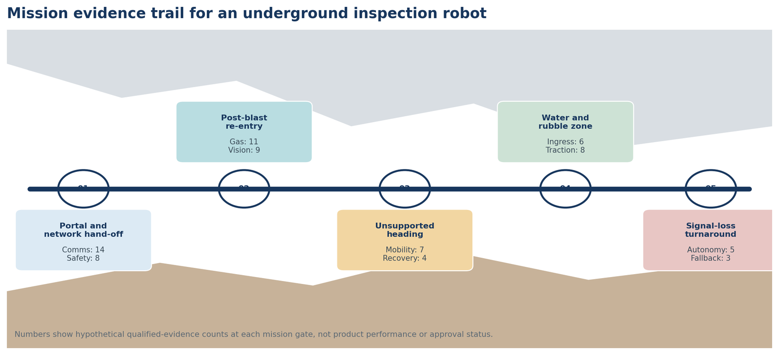
A worked output could show that tracked robots have the strongest evidence for payload stability and recovery on relatively consistent floors, while legged systems provide better obstacle negotiation but show fewer long-duration mine demonstrations and more complex recovery needs. Aerial systems may cover visual inspection quickly but remain conditional where dust, airflow, endurance or gas-sensor payloads constrain the mission. Tethered systems may solve data continuity and retrieval while creating snagging and route-length limitations.
How the example output should be read
The recommendation would combine platform and mission architecture. One route might use a tracked robot with a deployable radio relay for gas sensing and mapping, while a second uses a short-range aerial platform only for roof and void inspection after a ground platform has established communications. Evidence density at each mission gate would show where the shortlist is supported and where a field trial must be designed.
Deliverables and indicative schedule
DELIVERY PACKAGE
- Excel evidence base with approximately 168 screened records coded by environment, subsystem and task
- Mission-gate map showing evidence strength, failure modes and recovery dependencies
- Approximately 16 platform and supplier profiles with claim-to-demonstration traceability
- Field-trial question set covering route, payload, communications, autonomy, intervention and recovery
FIVE-WEEK WORKPLAN
- Week 1: route definition, mission gates and taxonomy
- Weeks 2 and 3: evidence search, screening and transferability coding
- Week 4: platform profiles, approval dependencies and gap review
- Week 5: mission shortlist, trial questions and quality review
Note: The five-week schedule is a planning assumption. Actual timing depends on mission breadth, mine and jurisdiction coverage, source accessibility, evidence quality and the number of platforms or approval pathways profiled.
WEBSITE PRESENTATION SUGGESTION
Use a scroll-driven underground route rather than a dashboard. Each mission gate opens a compact evidence card showing the required subsystem, strongest evidence, unresolved failure mode and proposed trial condition. On mobile, the route becomes a vertical descent. This visual language should not be reused for another service example.
Let's discuss your project
If your team is assessing robotics for a hazardous inspection, restricted-access route or mine-specific sensing mission, August Research can build the landscape around the operating conditions and evidence needed before a field trial.
Note: This illustrative engagement is a hypothetical website example, not a client project or actual finding. All counts, profiles, scores, findings, timelines and deliverables would change with the scope and available evidence. Secondary research does not replace regulatory, engineering, laboratory or operational validation.