STAKEHOLDER MAPPING | ILLUSTRATIVE ENGAGEMENT
Who must align before an urban cold-storage hub can proceed?
A stakeholder pathway study for a proposed multi-user hub in Greater Manchester, UK
THE BUSINESS DECISION A regional cold-chain operator was considering a shared urban hub providing chilled and frozen storage, order consolidation and coordinated delivery for independent food businesses. Before selecting a preferred site, the client needed to know which planning, infrastructure, operating, user and local-acceptance pathways could enable or delay the concept.
28 ENTITIES
Illustrative stakeholder universe
16 INTERVIEWS
Six pathway-specific groups
4 ZONES
Site to city-region system
7 WEEKS
Illustrative delivery window
Why the location mattered
The same operating model could encounter different constraints across Greater Manchester. Site access, nearby land uses, local planning responsibilities, transport connections, utility readiness and the concentration of potential users could change both the stakeholder universe and the order of engagement. Geography therefore became part of the research design rather than a label added to the example.
What the study needed to resolve
- Which stakeholders could control land access, planning permission, transport conditions, power availability or refrigeration delivery?
- What would potential users and delivery operators require before offering credible commitment to the hub?
- Which local concerns depended on proximity, operating hours, vehicle routing or evidence of community benefit?
- What sequence of validation would prevent the client from committing to a site with unresolved stakeholder dependencies?
WHY INDEPENDENT RESEARCH MATTERED The client knew several prospective users and property contacts, but those relationships could not represent the complete permission system. Independent outreach tested less visible dependencies and allowed participants to discuss concerns without being treated as supporters of a live development proposal.
All organisations, participant counts and findings in this illustration are hypothetical. They demonstrate a realistic research design and are not presented as market evidence.
02 | STAKEHOLDER UNIVERSE AND OUTREACH
Build coverage around the pathway, not a contact list
Twenty-eight hypothetical entities were classified by how they could shape site feasibility, user commitment, local permission or launch readiness.
Four proximity zones
1 SITE AND ADJACENCIES
Landowner, landlord, utility connections, access points and directly neighbouring businesses.
2 LOCAL ACCESS AREA
Local authority functions, ward or business groups, nearby operators and traffic-sensitive routes.
3 CITY-REGION SYSTEM
Transport, economic-development, environmental and sector bodies operating across Greater Manchester.
4 MARKET NETWORK
Potential users, delivery partners, refrigeration providers, insurers, financiers and industry relays.
Who was interviewed
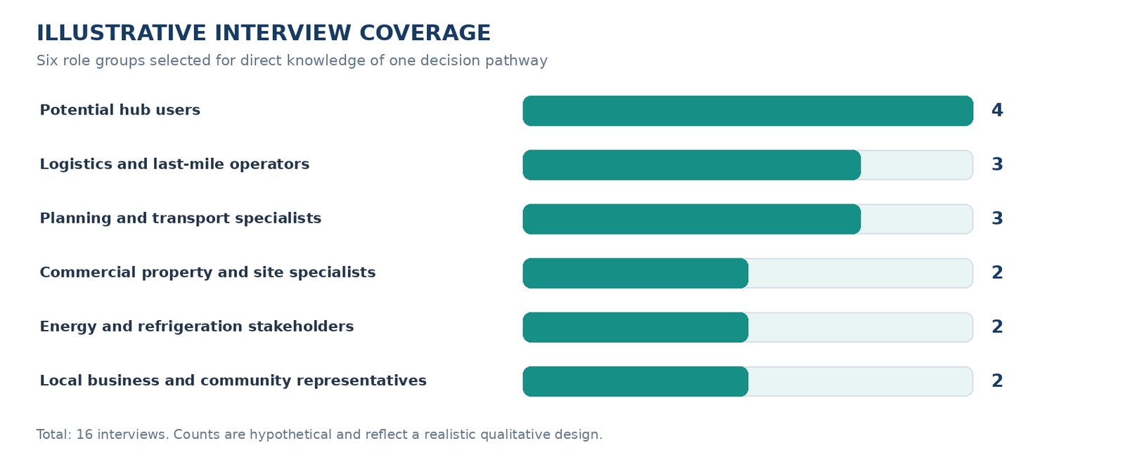
What the outreach looked like
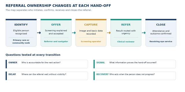
IDENTIFY Combine public records, client-approved contacts, independent professional networks, local business groups, targeted identification and relevant market partners.
VERIFY Confirm current role, location or market fit, direct knowledge of the relevant pathway and any commercial, advocacy or employer interest.
INVITE Use a neutral invitation describing a study of urban cold-chain operating conditions. Do not present the participant as supporting a proposed site.
VALIDATE Capture the route, condition, timing and evidence behind each claim. Retain disagreement and distinguish direct knowledge from inference.
ACCESS BOUNDARY Participation by serving public officials was not assumed. Where direct access was inappropriate or unavailable, official evidence and independent or former practitioners could clarify process without claiming an institution's current position.
03 | RESEARCH METHOD
Proximity-Gated Permission Mapping
The method connected the site decision to formal authority, operating dependencies, credible demand and the affected interests closest to each candidate location.
01 BOUND
Define candidate-site cells, service model and decision window.
02 TRACE
Build formal, operating and relationship pathways from available evidence.
03 LOCATE
Classify stakeholders by proximity, jurisdiction and dependency.
04 VALIDATE
Interview only where position, informal influence or conditions remain unclear.
05 SEQUENCE
Set pre-screen, engagement, evidence and monitoring actions by decision stage.
Sample interview questions
PLANNING AND TRANSPORT The proposed hub would concentrate loading activity at one site while consolidating deliveries across several users. From your experience of comparable developments, which access, operating or evidence conditions would need to be resolved before a site could be considered suitable?
POTENTIAL HUB USER Assume the hub offers flexible chilled and frozen pallet space with coordinated delivery. What volume, control, service or liability conditions would your organisation need before it could provide a credible indication of demand?
LOGISTICS OPERATOR Several food businesses may share the facility while retaining different delivery requirements. Which routing, loading-window and responsibility boundaries would determine whether the operating model is workable?
ENERGY OR REFRIGERATION The site would rely on continuous refrigeration and may face a constrained connection timetable. Which load, resilience, equipment or commissioning questions should be resolved before the client commits to the property?
LOCAL BUSINESS OR COMMUNITY The hub could alter vehicle movements and operating hours near neighbouring businesses or residents. What information would be needed to assess the local effect fairly, and which concerns should be addressed before formal consultation?
PROPERTY OR SITE The building must support temperature-controlled operations, loading movements and future user growth. Which lease, fabric, access or modification conditions could make an apparently suitable property impractical?
WHY NO BROAD SURVEY The decision depended on a small number of specialised pathways and site-specific conditions. A broad opinion survey would add volume without resolving authority, infrastructure or sequence. Targeted qualitative validation was the more defensible design.
04 | ILLUSTRATIVE FINDINGS
Three pathways had to converge before site commitment
The hypothetical analysis showed that user interest alone could not compensate for unresolved infrastructure or local-permission conditions.
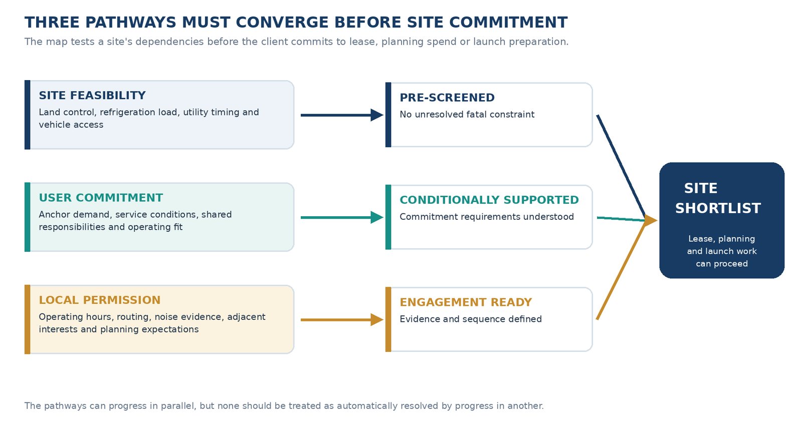
What the pathway analysis indicated
INFRASTRUCTURE BEFORE PROMOTION
Vehicle access, refrigeration load and connection timing needed pre-screening before the client encouraged user commitment to a specific site.
DEMAND AS EVIDENCE, NOT PERMISSION
Credible anchor-user conditions strengthened the case for investment but did not resolve planning, access or local-effect questions.
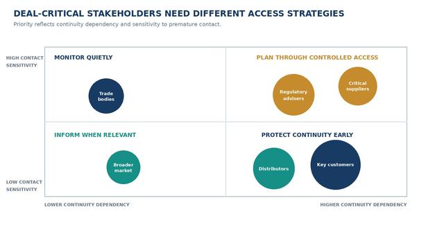
PROXIMITY CHANGED PRIORITY
Adjacent businesses required earlier engagement than city-region voices because operating hours and routing affected them directly.
RESPONSIBILITY NEEDED A HOME
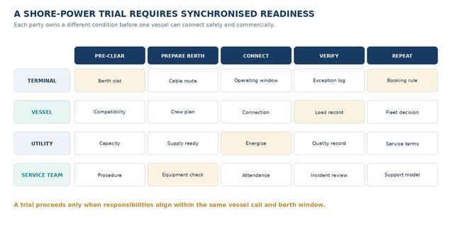
The shared model required clear ownership of temperature integrity, loading coordination, incident response and user onboarding before launch readiness could be claimed.
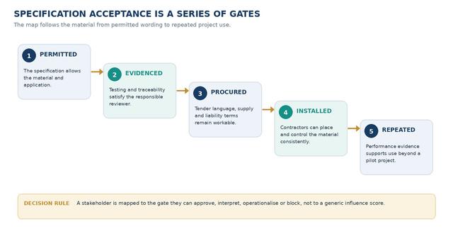
DECISION PATTERN The client should shortlist only sites that pass infrastructure pre-screening, have defined user-commitment conditions and can enter local engagement with a credible operating and evidence plan.
05 | DECISION AND DELIVERY
Turn the stakeholder map into a site-selection sequence
The output gave the client an order for pre-screening, engagement and evidence development rather than a static list of influential organisations.
Recommended decision sequence
1 PRE-SCREEN
Remove sites with unresolved access, building or refrigeration constraints.
2 TEST COMMITMENT
Clarify anchor-user demand and the conditions behind it.
3 PREPARE ENGAGEMENT
Develop routing, hours, noise and benefit evidence for local discussion.
4 COMMIT IN STAGES
Link lease, planning spend and launch activity to defined pathway gates.
What the client received
STAKEHOLDER UNIVERSE
Entity register with pathway, proximity, jurisdiction, relationship and evidence status.
SITE-PATHWAY MAP
Formal, operating, demand and legitimacy routes connected to each candidate-site cell.
ENGAGEMENT SEQUENCE
Who to approach, for what purpose, through which route and before which decision gate.
EVIDENCE AND MONITORING REGISTER
Unresolved assumptions, required evidence and signals that could change the map.
Delivery
TIMING
Approximately seven weeks
WORKING OUTPUTS
Weekly universe and evidence-gap review; emerging access risks flagged as they appear
FINAL DELIVERY
Editable stakeholder register, pathway visuals, site decision sequence and management readout
The timeline is illustrative and depends on the number of candidate sites, stakeholder availability, public-sector access, recruitment feasibility and client review time.
STUDY BOUNDARY The engagement would not provide legal planning advice, guarantee permission or predict stakeholder behaviour. It would organise available evidence, validate selected pathways and make uncertainty visible before the client commits resources.
Contact Us
MAP THE STAKEHOLDERS AROUND YOUR DECISION
Tell us the initiative, location and decision window. We will design the stakeholder universe, evidence review and outreach around the pathways that can shape the outcome.